Download the PHP package jackardios/laravel-eloquent-spatial without Composer
On this page you can find all versions of the php package jackardios/laravel-eloquent-spatial. It is possible to download/install these versions without Composer. Possible dependencies are resolved automatically.
Download jackardios/laravel-eloquent-spatial
More information about jackardios/laravel-eloquent-spatial
Files in jackardios/laravel-eloquent-spatial
Package laravel-eloquent-spatial
Short Description Spatial library for Laravel
License MIT
Homepage https://github.com/jackardios/laravel-eloquent-spatial
FAQ
Example:
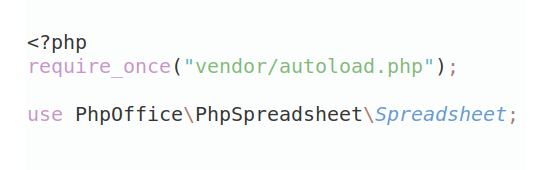
In general, it is recommended to use always a project to download your libraries. In an application normally there is more than one library needed.
- Some hosting areas are not accessible by a terminal or SSH. Then it is not possible to use Composer.
- To use Composer is sometimes complicated. Especially for beginners.
- Composer needs much resources. Sometimes they are not available on a simple webspace.
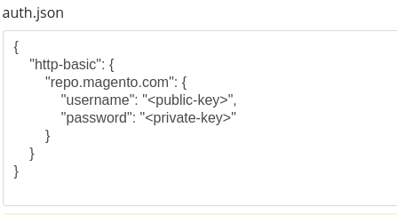
- If you are using private repositories you don't need to share your credentials. You can set up everything on our site and then you provide a simple download link to your team member.
- Simplify your Composer build process. Use our own command line tool to download the vendor folder as binary. This makes your build process faster and you don't need to expose your credentials for private repositories.
Informations about the package laravel-eloquent-spatial
Laravel Eloquent Spatial


Laravel package for working with spatial data types and functions in Eloquent.
This package is a fork of matanyadaev/laravel-eloquent-spatial, maintained by Jackardios.
Supported Databases
- MySQL 5.7 / 8.0 / 8.4
- MariaDB 10.11 / 11.4
- PostgreSQL 12–17 with PostGIS 3.4+
These are the versions that the tests run on.
Requirements
- PHP 8.3+
- Laravel 12.18+ / 13.x
For PHP 8.1 or 8.2, or Laravel 10, 11 or 12 before 12.18, use version 4.x.
Installation
Quick Start
1. Create a Migration
To restrict a column to one SRID, pass it to the column, for example $table->geometry('location', subtype: 'point', srid: 4326). MySQL 8 then rejects geometries with a different SRID.
2. Set Up Your Model
3. Work with Spatial Data
The geometries that a query compares must have the same SRID, so the examples use SRID 4326 throughout. Without an SRID, a geometry has the default SRID, 0 unless you change it.
Geometry Classes
All geometry classes support creating instances from various formats:
Each method reads only its own format: fromWkt() does not accept GeoJSON, and fromJson() does not accept WKT. Z and M coordinates are read and dropped. Factory::parse() detects which of these formats a string is in. It does not apply the default SRID: the SRID is the one in EWKT, EWKB or the MySQL format, and 0 for WKT and GeoJSON, while fromWkt(), fromJson() and fromArray() use the default SRID.
Available Geometry Types
| Class | Description |
|---|---|
Point |
Single coordinate (longitude, latitude) |
LineString |
Ordered sequence of Points |
Polygon |
Closed shape defined by LineStrings |
MultiPoint |
Collection of Points |
MultiLineString |
Collection of LineStrings |
MultiPolygon |
Collection of Polygons |
GeometryCollection |
Mixed collection of any geometry types |
BoundingBox |
Rectangular bounds with antimeridian support |
Coordinate Validation
The Point class validates coordinates automatically. With SRID 0 (the default) or 4326, the coordinates are degrees:
Other SRIDs have their own units, so their ranges are not checked. With any SRID, the coordinates must be finite:
Spatial Query Scopes
The HasSpatial trait provides query scopes for spatial operations:
Distance Queries
The operator must be one of =, <, >, <=, >=, <> and !=, and the direction asc or desc in any case. Anything else throws InvalidArgumentException, because these arguments are written into the SQL. The alias of withDistance() and withDistanceSphere() is quoted as a column name.
Spatial Relationship Queries
BoundingBox
The BoundingBox class represents rectangular geographic bounds:
BoundingBox as Model Attribute
The geometry is stored with the default SRID unless the cast names one. On MySQL 8, a column with an SRID accepts only geometries with that SRID.
SRID Support
Spatial Reference Identifiers define coordinate systems:
Extending Geometry Classes
Using Macros
Custom Geometry Classes
Parsed and database values are then created as CustomPoint. A Point::class cast accepts it, and GeoJSON and WKB write it as a Point.
Long-running processes (Octane, queue workers)
The classes registered with EloquentSpatial::use*(), the default SRID and macros are static, so they are shared by all requests that a process handles. Set them once in the boot() method of a service provider, never per request.
Dirty Checks
The geometry and bounding box casts compare values themselves, so models detect changes correctly without the HasSpatial trait. A change of only the SRID or only the geometry type, such as a Point replaced by a MultiPoint with the same coordinates, is saved.
Limitations
- MariaDB does not support nested geometry collections:
ST_GeomFromText()returnsNULLfor them, so such a value is saved asNULL. -
MySQL 8 reads WKT with a geographic SRID such as 4326 as latitude first. The package adds
'axis-order=long-lat'to the SQL it generates. If you assign a raw expression yourself, add it too: - Geometries nested more than 64 levels deep are not read. Such values throw
InvalidArgumentException, because reading them could crash PHP. - Empty geometries other than
GEOMETRYCOLLECTION EMPTY, such asPOLYGON EMPTY,MULTIPOLYGON EMPTY,LINESTRING EMPTYandPOINT EMPTY, are not read and throwInvalidArgumentException. PostGIS returns them from functions such asST_Intersection()andST_Difference(). A model whose geometry column holds such a value throws when the attribute is read, so storeNULLinstead. - The rings of a polygon are not checked to be closed.
POLYGON((0 0, 1 0, 1 1))is read from WKT and GeoJSON and can be created from points; the database rejects it when it is saved.
API Reference
For complete API documentation, see API.md.
Upgrading
See UPGRADE.md for upgrade instructions from previous versions.
Development
License
MIT License. See LICENSE.md for details.
All versions of laravel-eloquent-spatial with dependencies

ext-json Version *
ext-pdo Version *
brick/geo Version ^0.13.1
laravel/framework Version ^12.18|^13.0